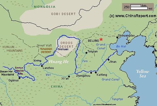
The Path o/t Yellow River through China (1) Upper Reaches ; Qinghai, Sichuan, Gansu.
The Yellow River is China's second longest river, measuring some 5464 kilometers (3.395 miles) in length. It is the world's 6th longest river.
The Yellow River is known in Chinese as Huang He and also as Huang Ho depending on spelling.
The drainage basin of the Yellow River, known as the Yellow River basin, is the third largest of all rivers in China, encompassing a surface area of around 750.000 square kilometers (290.000 square miles)(official: 742,443 km² (290,520 mi²).
It extends 1900 kilometers (1.180 miles) from West to East and 1100 km (684 miles) from South to North.
The China Report
Introduction to the Yellow River (Huang He - 黃河) - China's 2nd largest River
ChinaReport.comat
Madoi
The Path of the yellow river starts in the parts of Tibet today known as Qinghai Province where a small spring originates from the foothills of Bayan Har Mountains in South Qinghai Province (East Tibet) not far from the border with Sichuan Province.
To be exact, the river springs in the form of several streams from the Northern Slopes of the Bayan Har mountains in the Yekuzonglie-basin at a height of +/- 4500 meters.
The source section, still divided into many seperate streams, flows mainly through pastures, swamps and knolls between the Bayan Har Mountains (巴顏喀啦山脈) and the Anemaqen (Amnye Machin) Mountains.
Generally speaking, although a dusty unpaved road follows the Yellow River upstream for some distance, the very upper regions and wider source area can only be reached by riding animal or with use of tracked vehicles. In this very early section
Schematic Map of the Flow Path of the Yellow River through China.
In the past, up to 1976, these regions - Madoi County and larger Qinghai, were also known as the "Chinese Siberia". During the lenghty and tyranical rule of the Chinese Communist Party in the Peoples Republic of China after 1949 AD, consecutive waves of Political Persecutions jielded tens- if not hundreds of thousands of political prisoners (on top of the many murdered by execution). Considered as remote as could be, the entire Amdo Region (Qinghai) was considered perfect for the disposal of unwanted social elements and hence saw the rise of a multitude of often very basic concentration camps where inmates were required to labor for the state. Many who served did not survive the harsh circumstances of the eastern Tibetan Plateaux, the hunger and the hard labor. Others who made it through and were eventually released stuck around to join the Han Chinese settlers of the region. Although little information is available on the subject it is known that not long after the initial invasion of (Amdo and Kokonor) East Tibet by the Peoples Republic in 1950, the first forced laborers arrived in Qinghai. One of their initial tasks was to provide labor for the construction of the G214 Highway for the advancing army as did many freed Tibetan poor (serfs, as they are known in Communist language).
The permafrost’s melting seriously affects construction projects, such as road building, on the Qinghai-Tibet Plateaux. Due to the softening of the previously permanently frozen ground, the surface of the Qinghai-Tibet Road has become rough, easily leading to road accidents.
Some 115 miles beyond the first recognizable forms of a river the waters of the Peacock River, Ngari Creek (Kari Qu) and Yueguzongli River finally unite becoming the Yellow River only shortly before meeting first the Zhaling (湿地国际) and Eling (鄂陵湖) Lakes, both containing crystal clear waters. A modest half-high white concrete stele marks the spot with the inscription: "黄河源头" meaning Source of the Yellow River (although there are several sources all of which lie many 10's of kilometers beyond). Traditionally recognized among the many Tibetan sacred lakes, the current day names of the Lakes are misguiding and have been adopted only in recent decades, likely in order to erase from memory the fact that the Lakes are Tibetan and located in (until recently) exclusively Tibetan regions. Worldwide these Lakes are much better known by their Tibetan names as Gyaring Hu (Tibetan: མཚོ་སྐྱ་རིང་) and Ngoring Hu (Tibetan: མཚོ་སྔོ་རིང.) ,Hu meaning Lake.
At elevations over 4,260 meters (13,976 ft) above sea level they are the largest two plateaux freshwater lakes in the Peoples Republic of China today.
The First Lake is the Gyaring Lake (Tibetan: མཚོ་སྐྱ་རིང Tso-Kyarang) meaning "Long Grey Lake") which is the first point where the many small streams that flow out of the source region unite into one body of water. Due to the fact that the Yellow River flow stirs up a lot of sand while entering into the lake, the surface of the Gyaring Lake is not crystal clear but rather patchy alike a cup of tea when yak butter (or milk) is added.Thus, when the winds pick up the Lake displays deep blue and gray colors mixing. The Lake owes its name to the phenomenon, turning "long and gray(-white)" when the wind stirs the sand and sediments.
The first mass collection point of the waters that eventually will form the great Yellow River it is situated at an elevation of 4292 meters, measures a whapping 526 Square Kilometers and has a drainage area of 8161 km 2, a length of 35 km and an average width of 15 km (max 21.6 km). That is, originally. As is described below, the lakes, rivers and indeed the very source of the Yellow River have since seen dramatic changes, among things related to global climatic changes. As a result of rising temperatures, melting glaciers and mining activities, underground water sources and small streams have been drying up. In accordance, the first lakes of the Yellow River are also shrinking in size yearly.
The center of the lake off its northeast end is the deepest part of the Lake with the capacity of 4,600 million cubic meters.
Huang-
Ren
HaiBei
Hai-
Dong
Hainan
Golmud
Golog
Yushu
Baima
Mts
Shan
Tangula
Wenquan
Serxu
Yushu
Madoi
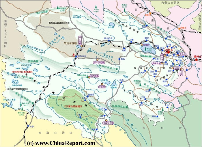
Geographical overview of Qinghai Province(EastTibet)inWest-Chinawiththemainregions,populationcenters,lakes, landmarks, monumentsandscenicsights.
Only briefly after flowing out of the eastern end of the Gyaring Lake the united flow of the water reaches the second body of water. The second lake is the Ngoring Lake (Tibetan: མཚོ་སྔོ་རིང. Ngorang or Long Blue Lake), situated at an elevation of 4268 meters and measuring 610.7 Square Kilometers, with a drainage area of 18,188 km 2, a length 32.3 km and mean width of 18.9 km (max 31.6 km). The center of the lake off on its north side is the deepest with a depth of 30.7 meters, a capacity of 10,700 million cubic meters. Contrary to its twin, the Gyaring Lake, the Yellow River carries little sediment into the Ngoring Lake with as a result that the Lake usually has a deep blue-green color after which it has been named.
As with the Gyaring Lake, Ngoring Lake lies in relatively flat land and is surrounded by swampy zones and green pasture lands and is usually recognized as an important wildlife refuge in the region. As recorded, The swamp area's around the lake serve as a useful breeding and roosting ground for various rare migratory birds, endangered crane species of other more common water-birds. A small rock-like island in the center of the Gyaring Lake serves as a suitable nesting ground for Cormorants, bar-headed goose, ruddy shell-duck and other birds and is as such known as the "Bird Island".
As was discovered early in the 20th century by foreign biologists and zoologists both Lakes are cold and nutrient poor, for which reasons only especially well adapted fish species can thrive in the Lakes. Through the work of various scientists over the last century both large upstream Lakes are known to provide unique high altitude habitats to a number of unique fish-, and other species. Previously protected by their ultra-remote location, the inhospitable climate and the traditions and customs of the Tibetan people these species now find themselves endangered by modern developments in the area and climatic changes sweeping the Tibetan Plateaux.
Among things, while wildlife in general was sacred in traditional Tibetan culture and more specifically fish was never eaten, eversince the Chinese take-over of Tibet Han Chinese migrants entering the region have started commercial fishing in the lakes. Where all animals
Several miles beyond Ngoring Lake and some 180 miles from the first recognizable signs of a real river the River of the Peacock, by then united as Yellow River, reaches the county Town of Madoi, the first sizeable town found along its trajectory in East Tibet (Amdo), now Qinghai Province.
Madoi (Tibetan: རྨ་སྟོད་རྫོང ; Maduo) is the only county Town in this central part of the Golog Tibetan "Autonomous" Prefecture of Qinghai Province and as such the center of Madoi County. Over the recent decades it has functioned as a small market town where the nomadic peoples of the county, counted as some 10 thousand in 2010, can buy their supplies and where authorities had established their presence.
More recently, while droughts and desertification have forced the Government into large scale settlement and resettlement plans for large parts of the remaining nomadic population of the County and Prefecture, Madoi has grown in size, the new citizens being former nomadic herders who have traded their animals and nomadic lifestyle for a concrete apartment in town and a monthly stipend from the Government. It is a bleak life, as their are few job opportunities on this remote section of the Tibetan Plateau where the only sizeable industry today is the Chinese run mining industry. Even the mines will not need this unskilled labor force. Economic marginalization seems to be the inevitable future for the once proud and independent nomads of Tibet.
SAN JIANG YUAN - SOURCE REGION OF THE THREE RIVERS:
Just beyond the town of Madoi the Yellow River enters a large region that is in China also identified "Sanjiangyuan", the area or region of the source of Three of the most famous Rivers in all of China and Asia; these of course are the Yangtze River, the Mekong River and the Yellow River. Traditionally a thinly populated region inhabited by groups of nomadic herders, their sheep and yak, over recent decades the region has seen increased competition for the dwindling natural resources of the region, among things leading to drastic overgrazing by extensive herds.
Recently, beginning in 2003, the region has been targeted by the Central Government of the Peoples Republic for a massive conservation effort, in effect with the plan to turn the region into the the 2nd largest National Wildlife Conservation Park on the planet. The Park, by now created has a surface area of roughly twice the size of the Chinese Province of Shandong.
DARLAG AND DARLAG COUNTY:
Gyümai (or Jímài (吉迈) for short, but also known as Darlag) is the main county Town of Darlag County of the huge Golog Tibetan Autonomous Prefecture. The town lies at some 112 miles beyond Madoi along the river and counts only some 400 inhabitants (according to the sparse sources) while the entire county counts only some 30 thousand dwellers (10), many of whom still live a nomadic life-style or attempt to do so. The County of Darlag, the vast area surrounding the town, measures some 15385 square kilometers.
Cloud Seeding or Cloud Busting?:
Both the Gyaring and the Ngoring Lake have decreased in size considerably and their waterline is predicted to retreat further as global temperatures increase and feeding gletsjers retreat and eventually disappear altogether. In order to attempt at least something to try and avoid what seems inevitable
In addition to the melting of the eternal snows and glaciers, over the past decade or so, snow and rain have become less frequent on the grassy lands of the east Tibetan Plateaux and the abundance of small creeks and ponds used by the traditional nomadic herders who (used to) inhabit the region have started to dwindle and dry up, leaving a parched and increasingly dusty landscape.
As reported by National Geographic in the article: "Bitter Waters, can China save its Yellow - its mother river?". By may 2008 - now over 6 years ago, more than 3,000 of the 4,077 lakes within the Qinghai Province's Madoi County had disappeared, and where previously lush grasslands and even deadly swamps formed a green but inhospitable landscape, the grass has turned yellow and sandy deserts have appeared. Ever advancing since, the dunes of the high desert now lap menacingly at the few streams and lakes that remain in the wider regions. As the Yellow River is known to receive as much as 50% of its total water volume from the Amdo and Kokonor Regions of Tibet (Qinghai) this is of the most serious concern to the entire Peoples Republic and in fact to all of East- and South East Asia. The glaciers, are shrinking at a rate of 7 percent a year. As National Geographic observes; "Melting ice may add water to the river in the short term, but scientists say the long-term consequences could be fatal to the Yellow River".
The results of a Chinese survey publlished in 2005 and re-printed in the mouthpiece National Newspaper Xinhua say that in the past 50 years, the average temperature in the region near Madoi County in Northwest China’s Qinghai Province - which means at the source of the Yellow River, has risen by 0.88 C.
Although that appears to be but a minute rise, in practice even such a small rise in temperatures and resulting shifting of according winds can have a dramatic impact. In the past 30 years, the region has lost 17 per cent of its glaciers and 2.39 billion cubic metres of water directly. The rate of melting ice is 10 times faster than it was in the previous 300 years. As such, the biggest and most urgent problem facing the regions is now climatic change. Unfortunately, not much can be done about that locally and so the future looks very grim for Madoi County, the Yellow River and other rivers that originate from the regions.
were freely allowed to thrive up till the year 1950 AD, in modern times the fish stocks have dwindled compared to the old times and some species of the rare and exotic fish found only in these lakes have already gone extinct. An official fishery industry was established in 1978 delivering the slowly reproducing cold water scaleless fish, spotted carp, Ceratodus and Huanghe (Yellow River) carp and three-eyed fish to hungry Chinese markets. It was a smashing commercial success with no sustainable basis whatsoever. As a result, already by the 1980's already the Government found itself forced to impose limits on fishing within the Lake. Regardless the efforts, the fish stocks in the Lakes have continued to fall year upon year.
the river has several branches and flows through mostly uninhabited regions considered as ultra remote even today.
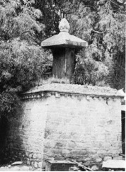
The Cow Head Stele (niú tóu bēi 牛头碑):
In September of the year 1988 the civil administration of Maduo County proudly unveiled a new monument near the source of the Yellow River in the county. Most popularly known as the Niu Tou Monument or Cow Head Stele it is a monument hailed by the propaganda and tourism industry as "the soul of China". Although Madoi County is still considered as an ultra-remote destination, the stele in the style of a cow head at the source of the Yellow River" is a increasingly popular and somewhat extreme tourist destination and landmark.
Although this is not always explicitly mentioned by tour-companies offering travel packages to Foreigners eager to travel the Madoi County and 1000 Lakes region, the Oxen Head Stele is a monument dedicated to a Tang Dynasty Era Princess, the legendary Princess Wencheng (wén chéng gōng zhù 文成公主) , who married the Tibetan King Songtsän Gampo (Tibetan: སྲོང་བཙན་སྒམ་པོ་ ; Chinese: sōng zàn gànbù 松赞干布)(Life: 605 AD - 650 AD), thus bringing Peace and Harmony between the previously feuding and warring Tibetan People and the Han Chinese of the Tang Dynasty Empire (618 AD - 907 AD) of China. An Important historical event indeed, albeit not for the very reason usually advertised via official Chinese Government media channels and usually thus echoed by local tourist agencies and the like. Indeed, although none of this is entirely certain at this time, many historians today agree that Princess Wencheng did marry the Tibetan King, resulting among things - as it is said - in the peculiar and thus unique designs of the Holy Jokhang Temple in Lhasa (other ascribe the features of this Temple entirely to the Nepalese Princess). However if the marriage tale ever played out as it is told by historians today, it was far from what it is advertised like in the Peoples Republic of China, which is that the marriage was a gift and generous gesture of genuine friendship with the Tibetan People made by Tang Emperor after their defeat at the hands of Tang Armies. This tale, however romantic it may seem does not concur with the true historic narrative. That is, contrary to what is often believed, the Tibetan People were not defeated and subjected by the Tang Dynasty Armies accepting a Chinese Princess as their new Queen. In reality, the Tibetans defeated the Tang several times over and in the end it was the Tibetan King who made his demands, not the Tang Emperor. A seemingly small but in fact major twist of historic events.
given current policies and human actions, the Chinese Central Government has launched a massive science based attempt to increase the precipitation in the regions by "seeding rain clouds". As for the uppermost reaches of the Yellow River and the Gyaring and Ngoring Lakes, this means that (according to National Geographic) "during summer months, artillery and planes bombard the clouds above the Yellow River's source area with silver iodide crystals, around which moisture can collect and become heavy enough to fall as rain". Thus, huge explosions regularly shake the regions and the town of Madoi, both day and night. Although it is reported that the cloud seeding project has indeed increased rainfall during the summer months, few local inhabitants are convinced the project will achieve any long term result. On the contrary, most experience it as yet another Government infringement into their otherwise remote and quiet lives. Such emotions are further reinforced by traditional beliefs that the disturbing of the natural state of Mountains and Lakes will enrage the Gods, acts which in return are bound to
YouTube Video by Greenpeace: Tibet is melting into a Desert.
result in the coming of misery, an expression of the wrath of the often malignant and violent traditional Tibetan and Mongolian deities.
Having passed northward out of the Ngoring (Eling) Lake, the River of the Peacock (Yellow River) meets the first dam currently built across the river near the village that is oddly named Zhalinghu (xiang)(=Zhaling Lake Village) eventhough it lies on the Eling (Ngoring) Lake. The dam serves as one of the measures that ensure an overrapid emptying of the already dwindling lake. A modestly sized reservoir lake has formed behind the barrier widening the pre-existing lake bed and swallowing some of the swamps and grasslands.
A narrow unregistered and unmarked dust road leads from the north bank and across the dam to the village, a drab collection of mud and brick colored buildings. Half of them seemingly ruined and only in use during hunting, game and perhaps tourist season. In practice, today there is no such fishing village anymore and people have moved to larger population centers. The same unmarked dusty road leads away further upstream to pass along the shore of the the neighboring Gyaring Lake and along the river.
In order to safeguard the fragile eco-system on the high plateaux from further damage by human infringements as well as safeguard the quality of the water of the source regions, large groups of the nomadic peoples have been driven off their ancestral grazing lands, ultimately to be settled in Madoi or larger population centers such as Xining or Chengdu, where they are swallowed by the majority Han population. Whole population groups are marginalized in this way losing any hope for a bright future. Hence, alcoholism has become a major social problem in rural and remote East Tibet. Those who cannot adapt often end up committing suicide. In a region lacking in trees
some such individuals drown themselves in the river. (Read more about the suicide epidemic along the Yellow River in: "Floating Bodies of the Yellow River" , Lanzhou, Baiyin Prefecture and other parts)
Apart from the resettlement efforts that should end overgrazing of the grasslands and resulting desertification, a series of measures have been announced to preserve the water quality of the headwaters of the three rivers. Althoughbetween 2003 and 2012 as much as 7.5 billion Yuan (RMB) or roughly 1 billion U.S. Dollars was expended on the effort to clean up the Three Rivers Region, resulting in massive deportations, it must be noted that at the same time a boom of mining activities ongoing throughout Qinghai Povince including the Golog Tibetan Autonomous Prefecture seems to contradict entirely with this plan. Mining activities are by now a leading cause of water pollution in East Tibet (Qinghai) as they are in other mining regions.
Although in the year 2004 Government plans to build several additional large hydro-electric dams in the regions, in the upstream of the Yangtze River as well as in the Salween River (Nu Jiang) including the famous Tiger Leaping Gorge, were halted due to severe environmental, ecological and long term viability concerns - under the new 5 year plan (edition 12; 2011 to 2015 AD) as many as 50 new dams are planned to be built in Chinese Rivers. Naturally, this entirely contradicts the conservations plans for the Three River Region. Pressed by massive needs for energy to drive the economy yet forced to reduce green house emitions, it seems the Government has since prioritized economic growth over the planned conservation effort, once again.
Source Documentary
"Kekexili Mountain Patrol"
( available as direct view video ! )
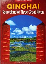
Source Book
"Qinghai, Sourceland of Three Great Rivers"
( available from our Online Store )
G214 National Road or Qinghai-Tibet Highway:
Situated on the north bank the town of Madoi lies along an ancient trade route which, for over 1500 years, extended between the cities of Xining and Lhasa. Where in the past centuries great congregations of yak, men and horses passed over the grasslands and camped and drank at the lake without any road or presence of a building in sight, today the town is connected to the outside world via the G214 National Highway, a road originally developed to allow the Chinese Peoples' Liberation Army to invade the Nation of Tibet and reach its ancient Capital of Lhasa (in 1950/51). The G214 road has a bridge across the Yellow River just south-west of town which is the first bridge to be found along the length of the river.
Quite some history could be told about the sacrifices made in order to allow for the construction of the G214 National Road. In the now almost forgotten Tibetan War of Resistance against Chinese Occupation (1959 - 1973 AD) the road was a favored target for Tibetan Guerilla's and many lives were lost along its length.
The Madoi County is the highest county (by average height) in all of the Peoples Republic of China today. Its climate is both extreme and highly variable over the day, although as part of the climatic changes temperatures overall are on the rise increasing survivability for humans. Despite the climatic "improvements", travel along the G214 National Highway is not for the fainthearted. The high altitude makes for thin air and as a result any physical strains must be kept limited in order to prevent headaches. Bright sunshine, unexpected rain, hail and high winds add to travelers woes.
Other animals found around the lakes are Tibetan antelopes, Tibetan wild donkeys, foxes, and of course the ever present eagles. Vultures are far less frequently than in previous decades.
The pasture lands surrounding the Lake are traditionally contracted out (leased) to local nomadic families who in the 1980's still counted around 1800 in number. Today, 30 years later, the number of nomadic families has fallen dramatically.
From the Bayan Har mountains the river flows and swirls through across the eastern Tibetan plateaux to curve around the Amnye Machin Mountains. Apart from the major town of Madoi, and many miles beyond the lesser settlement of Darlag (达日) also; Gyümai, there are no sizeable villages or urban setllements found along the river.
Re Creek (Re Qu) and Hei River (Hei He):
Some 60 kilometers downstream from the town of Madoi lies the town of Huanghe (xiang) near which the Yellow River is joined by two tributaries. The first tributary river is the Re Qu, which flows in from the south and is joined by the Hei (he) River just before it joins up with the greater Yellow River. (This Hei River is not to be confused with the longer Hei River also known as Ejin Gol (Black River) found in the Hexi Corridor of Gansu Province and the desert of western Inner Mongolia Autonomous Region). The Hei River flows in from the regions far south of Madoi and flows through the Galala Co (Co = Lake) before arcing eastward, meeting the G214 Qinghai-Tibet Highway and reaching the Re Qu and the Yellow River beyond.
Many many kilometers further downstream on the outskirts of the minor Town of Gyümai (Darlag) Town the Yellow River meets the S101 County Road which roughly follows the curving of the river for a few miles on the northern bank until it leads away northward from a point known as Tanggama.
STARRY SEA OF AMDO IN TIBET :
Once having reached the wide valley floor between both mountains ranges, the water collects in small ponds, bogs, swamps and lakes which used to form a beautifully pristine yet also notorious and deadly landscape. Fed by melting waters but also aquifers sprouting water from the earth the valley floor of the entire source region of the Yellow River was frozen solid in winter. However, come spring time melting waters quickly saturated the top layers of the soil with water creating a marshy landscape in which lakes occurred in such abundance that the region was Nationally renowned as the "County of a 1000 Lakes". Just because the crystal lakes appeared in such high numbers, infinite alike the stars in the sky above, the valley of the Yueguzonglie Basin was also known as the "Starry Sea". One of the larger Lakes in this vast and deadly swampy area even carried the same name of Xingxiuhai (Starry Sea) and because of its remoteness, altitude, size and appearance this lake was considered to be the source of the Yellow River throughout the earlier Chinese Dynasties.
As a part of territory of the Nation that became Tibet in the 7Th Century no Chinese had found opportunity to return there for further explorations until the 1970s when a now famous CCTV Film Expedition traveled the entire 5000 mile length of the Yellow River documenting the many cultures and landscapes found along its pathway. As shown in their thrilling multi-part documentary, with substantial effort the expedition did venture beyond the Starry Sea lake and were finally able to identify the ultimate origins of their beloved mother river and mark the spot.
Having reached their ultimate destination, in remembrance of their epic adventure and with an obvious emphasis on the Chinese claim to this originally Tibetan territory, the members of the expedition erected a concrete stele which today still stands at the source of the Yueguzongli River, one of the three main flows within the source area. Situated in a featureless grassy plain, at a point well over a 150 kilometers beyond the last signs of civilization presented by the sparse few buildings of the village of Maduo (xiang) (NOT Madoi Town!) this stele is very difficult or near impossible to reach.
The Starry Sea Lake itself, once hailed as the seat of the mother god of the Yellow River, has sadly since disappeared suffering from climatic changes. Likewise, many of the stars in the starry sea have faded.
Filtered through sand, rock, bogs and grass the eventual resulting three rivers are known to have crystal clear waters while flowing steadily between the rolling hills and grassland with the summit of the 6282 meter high Amnyae Machin Mountain visible in the distance. The Amnye Machin Mountain, with its five subordinate peaks known as the family members, is one of the 21 holy mountains in Tibet and the source region is the richest high altitude habitat in all of the Peoples Republic (of China), a home to 70% of all high alpine species found within continental East Asia.
The main stream of the Yellow River in this area is known as "river of the peacock" (Tibetan: རྨ་ཆུ་; Wylie: r Ma chu, p maqu 玛曲) or Yogilangleb Qu. The other two streams that eventually join the river of the Peacock are the Kari Qu (or Ngari) and a stream identified as the Yueguzongli River. Although the region is by far not as disconnected from the outside world as but a few decades ago, only a few small villages consisting of a few buildings can be found in this wider source area today.
Unique Source
5 DVD Set
"Yellow River"
Record of the Yellow River Expedition.
( NOT available
from our Online Store )
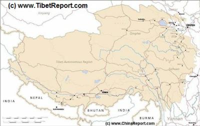
MapTibetHistoricalBorders
A Schematic Map of Historical Tibet, today Tibet Autonomous Region, Qinghai Province and a part of Sichuan province.
Included for reference are current International Borders, provincial borders, locations and names of main cities and towns, main rivers and lakes, mountains,importantTibetan-BuddhistMonasteries and other places of significance.
Further Reports link to More Photos and History & Backgrounds of each City, Town or Ethnic Community of Yugur, Dongxiang Tibetan, Lhoba, Kazakh, Mongol or others where available.
Today Tibet only exists as Tibet Autonomous Region of China. Tourist visits require an aditional visa !
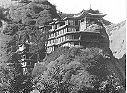
As proudly advertised, the Niu Tou monument was not only built to reinforce the (myth of a) Chinese claim to Tibet, but it is also a local investment made in the hope of helping the still fledgling tourist industry in these far flung parts. The strategy has so far worked in part and tourists now frequently travel along the lake shores in 4 wheel drive vehicles in the summer months. Further down the G214 Qinghai-Tibet highway in the town of Gyêgu (Do)(Tibetan: སྐྱེ་དགུ་མདོ་ ; Chinese: Yushu), another such monument has arisen, this being the Princess Wencheng Temple. Although the Wencheng Temple in Gyegu (Yushu) is a beautiful construction this well visited location is but a recent creation which exists mainly for the esthetic needs and wishes of the touring tourist community. Its visitors, many of whom are Chinese tourist, have little or no knowledge of how (roughly) the same site used to be occupied by a small Buddhist Monastery which was unfortunately raised to the ground in the early 1950's during the initial assault and Chinese invasion of Tibet. This same small Monastery, of which now but 1 known black and white photo remains, also happened to be the very Monastery where the late elder brother of the current 14Th Dalai Lama Tenzin Gyatso had received his initial religious training, completing this just prior to its destruction.
The stele in the shape of an oxen head, in theme with the nomadic traditions of the original people of the land, the Tibetans, is founded of pure copper weighing a staggering 5.1 tons is inscribed with the text proclamation "the headstream of the Yellow River" in both Tibetan and Han languages. The scripts are supposedly by the hand of the late tenth-generation Panchen Lama (which seems to be rather a stretch) and former Party Secretary and later discounted Communist Party member under House arrest Hu Yaobang, a man who's good name is in this way abused to support a cause he warned against in the years before his downfall as Party Secretary.
The locally much resented Cow Head stele (its really an oxen head) lies on Cuorigaze Mountain which is situated 92 kilometers away from Madoi Town on the land found between Gyaring and Ngoring Lakes. There it is found roughly halfway between the northern and southern shores of the Lakes and is reachable via an unpaved road which may have been upgraded (since 2010). Overlooking both the Gyaring and Ngoring Lakes from an elevation of 4610 meters, the site provides a spectacular viewpoint and photo-spot. The monument itself, surrounded by Tibetan prayers flags is made up of a 2 meter high mound atop which sits the three meters high stele-seat. A copperplate mould with the mentioned text is inlayed.
Miniature of the one photo of the Shadzong Ritr Monastery of Gyegu, now destroyed.
As it is told in the (Chinese) tale of Princess Wencheng and the handsome Tibetan King, the Princess left Chinese Territory at around the year 640 AD, traveling down what today is the route of the G214 National Highway (Qinghai to Tibet) from the Chinese trading stronghold of Xining. Having traversed the wild and empty grasslands of the Amdo Province of Tibet (at the time held by an as yet non-Tibetan tribe) via the ancient trading and pilgrimmage route. Having reached near the current day town of Madoi her extensive ceremonial caravan then met the Tibetan Delegation (and perhaps the King himself) at a location on the shore of the Long and Blue Lake (Ngoring Hu) from whence she traveled onwards to Lhasa. For this very reason, the cow head stele monument has been erected at the Ngoring Lake.
The historic accounts however reveal a slightly different reality, although - through lack of source material - nothing is entirely sure. The historic accounts do register a Chinese "wife" of the Tibetan King. In Tibetan history and memory she is recored as Gyasa, which translates as Chinese Wife. However, there is no clear information as to her status. In the Chinese Tale, Princess Wencheng becomes the benevolent queen of the Tibetan Nation, among things (together with the King's Nepalese wife Bhrikut Dev.) introducing Buddhism into Tibet from China (historians say Buddhism traveled from India through Tibet and surrounding Nations and Kingdoms to China via the Silk Road).
Yet, at the same time Chinese historical records do reveal that in the year 634 AD, 6 years previous to the supposed arrival of Princess Wencheng, Songtsän Gampo did request to have a Chinese Bride (as part of a diplomatic treaty package) but was turned down by the angry Tang Court. This is generally accepted as part of history and fits with an alternative narrative that says that Princess Wencheng was only received later on, after another campaign of war had defeated the Tang forcing them into a groveling surrender and the sending of the niece of the Emperor Taizong, along with a cartload of pure gold.
(in the years 635 and 636 AD Songtsän Gampo launched his armies up the route today taken by highway G214 subduing his valued trading partners the A Zha People (Chinese: tǔ yù hún 吐谷浑) who then became part of his rising Kingdom. The taking of the Kokonor (Qinghai Lake) Region added this strategically crucial region, a footstep onto the eastern Tibetan plateaux, to his rising Kingdom. The Princess could only have been received after the regions had been pacified).
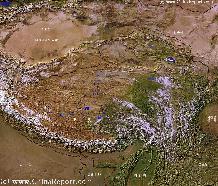
Tibet-TibetanPlateaux-SatelliteImageOverview 1A
A SatelliteImage overview Map of the entireTibetanPlateaux including parts of bordering regions of Xinjiang-UyghurAR, Gansu Province, NingxiaHuiAR, Inner-MongoliaAR,Sichuan Province,andYunnan Province. Surrounding nations and Territories are: Myanmar (Burma), Bhutan, Sikkim, Nepal, Bangladesh, India, Kashmir and Pakistan.
This Map clearly defines Provinces and Regions, main mountain ranges, main rivers & lakes of the region, locations of main cities and landmarks.