A Satellite Image Map of the Entire Gobi Desert Region and the realtive position of the City Datong in it. Map overviews North-West Xianjiang Autonomous Region, Mongolia, Inner Mongolia and North and North-Eastern China giving a Full Overview of the Gobi Deserts. Clearly visible details of geographical features such as mountain ranges, rivers, valleys and lakes, national borders, name and location details of Cities and Villages (clearly visible).
Mouse over Image to Reveal more information and follow the flow and path of the yellow river from Xining in Qinghai Province to the Bohai Sea. Details of old / former Yellow River flow (south of new) and new trajectory to the Bohai Sea.
The Qinghai Province Maps Index gives acces to all Maps relevant to Qinghai Province (Formerly Amdo Province of East Tibet), Tibet AR & Area's of Specific Interest within that Region, as used and/or produced by ChinaReport.com. Please use these Maps to find your way easily around the Region, Cities, Area's and many Monuments & Landmarks.
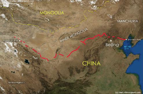
A Satellite image Based Map of China and East-Asia, with a super-imposed schematic Map of the Location and Path of the Great Wall as constructed during the Reign of the Ming Dynasty.
Included for reference are Locations and Names of Passes on the Great Wall of China and their significance. Further Reports link to More Photos and History & Backgrounds of each Great Wall of China Site. Further depicted are City names, geographical features of landscape, rivers and more.
Geographic Maps of the Silk Road Path through Qinghai, Cities , The Great Wall of China and location of Passes of Qinghai Province.
Maps relevant to Qinghai Province & History
Map o/t Taklamakan Desert & Tarim River Basin (in Xinjiang-Uygur AR)
A Satellite Image Map of the entire Taklamakan Desert and the Tarim River Basin in Xinjiang-Autonomous Region of Western China.
Map gives explanation and backgrounds to Local Geography, the Flow of the Tarim River from the Pamir Mountains in the West to Lop Nur (Dry) in the East, ancient Oasis Cities of the Tarim Basin and Taklamakan Desert, the North and South Routes of the Silk Road in this Area, Past and Current Climate and Historic Backgrounds.
Geographic Maps on Xining and Area of QinghaiProvince in Tibet.
Xining City & Prefecture Maps
Gansu Province Map 3 - Satellite Map
A Satellite Image based Map of Gansu Province entire and neighboring provinces clearly depicting the natural terrain features that shaped the Province of Gansu in History. Browse around the Image to the outlines of the Gobi & Tengger Deserts, view the Qinghai Plateaux extending from the West providing borders with Gansu Province and Sichuan Province. Central Gansu Province around the Capital of Lanzhou is formed by the Loess Plateaux and the flow valley of the Yellow River (Huang He). Otherwise distinct areas are the Throat of China, Hexi Corridor extending to the North-West and the Ningxia Yellow River Valley, a separate autonomous region and green patch in the North-East.
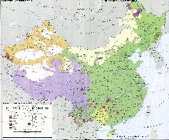
Map China Ethno-Linguistic / Language Distribution China
A Full and complete Map of China (PRC) identifying all Language Areas big and small in all Provinces and Autonomous Regions of China.
Map includes Turkic Languages (Uygur, Kazakh, Kirghiz, Salar & Uzbek), Mongolian Language and Sub-Divisions (Mongol, Tu, Daur and Dongxian), Tungusic Peoples (Oroqen, Evenki and Xibe) and Languages, Korean, Tajik (Tadzhik), Mon-Khmer (Kawa + Puman (or Pulang)), Hui, Uygur (Uighur), Tibeto-Bhurman Languages, Tai and Miao, Yao and She' Language Area's and Borders. Main Area's and sub-divisions of Han Languages (Northern Mandarin, Eastern Mandarin, South-Western Mandarin and Cantonese) further included. This color-coded ethno-linguistic Map (of 1967 AD) identifies at a glance most ethnic minority regions in China.
A Full Google Earth Supported Map of Qinghai Province by Google.com.
The China Report introduced on Levels of its Online Publishing's in April of 2009, including Tibet ARinApril2010.
Find Google Maps on nearly all Report & Photo Pages where appropriate and useful.
Adjacent Map gives direct access to Map Of Qinghai Province by Google.
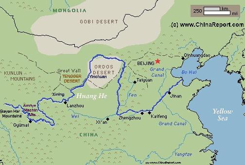
Schematic Map of the Yellow River Flow Path 01A
A Full Schematic Map of the entire flow path of the Yellow River. Map overviews Qinghai Province, Parts of Sichuan Province, Gansu Province, Ningxia Hui Autonomous Region, parts of the Republic of Mongolia, Inner Mongolia Autonomous Region, Shaanxi Province, Shanxi Province, Henan Province and finally Shandong Province, giving a Full Overview of the length of the Yellow River. Clearly visible details of geographical features such as mountain ranges, rivers, valleys and lakes. The Map includes main cities along the River, popular and famous scenic spots, the dams and water reservoirs on the Huang He and other relevant informations.
Click the links to find more information on each individual location !
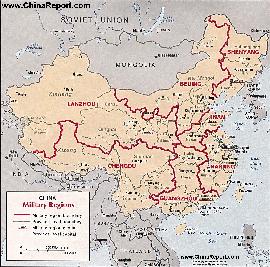
Map China 7 Military Districts (Regional Defense Commands)
Originally thirteen military regions were established in the 1950's, but the number was reduced to eleven in the late 1960's. The resulting eleven military regions - Shenyang, Beijing, Lanzhou, Xinjiang, Jinan, Nanjing, Fuzhou, Guangzhou (including Hainan Island), Wuhan, Chengdu, and Kunming - were reduced to seven intheperiod 1985-88 AD. Currently,the active military districts include Lanzhou- including the former Urumqi MR, part of the Himalayan Mountains in North-West Tibet andAksaiChin, Chengdu Military Region including the former Kunming MR, Nanjing, which includes the former Fuzhou MR, Beijing, and Shenyang. Finally Guangzhou and Jinan Military Regions both appear to include parts of the former Wuhan MR.
The military regions arefurther divided into military districts, usually contiguous with provinces, and military sub-districts.
Tibet - Qinghai-Xining City & Prefecture Maps - All :
Geographic Maps on Golmud City and Area in Qinghai Province.
Golmud City & Prefecture Maps
Tibet- Qinghai - Golmud City & Prefecture Maps - All :
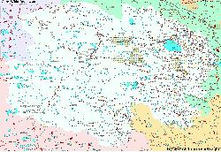
Qinghai Province Map 1 - Geographic Map
A Geographic overview of Western China's Qinghai Province entire, delineating Provincial Borders and parts of neighboring Xinjiang-Uygur Autonomous Region, Gansu Province, Sichuan Province and Tibet (Xizhang) Autonomous Region. Includes Cities and Towns (shown by size), Main Monuments & landmarks, the flow of the yellow river in Qinghai Province, surrounding Bayan Har Mountain area's (TengGer), locations of Ethnic Minority Enclaves in Qinghai Province, Main Mountains (with Height), major highways, provincial railroads and main railroad-stations and main waterways & rivers. This Map further provides links to on site photos and information on Cities, Monuments and main transportation hubs of the wider Region.
Qinghai Province Map 2 - Schematic Map
A schematic overview of Western China's Qinghai Province entire, delineating Provincial Borders and parts of neighboring Xinjiang-Uygur Autonomous Region, Gansu Province, Sichuan Province and Tibet (Xizhang) Autonomous Region. Includes Cities and Towns (shown by size), Main Monuments & landmarks, the flow of the yellow river in Qinghai Province, surrounding Bayan Har Mountain area's (TengGer),locations of Ethnic Minority Enclaves in Qinghai Province, Main Mountains (with Height), major highways, provincial railroads and main railroad-stations and main waterways & rivers. This Map further provides links to on site photos and information on Cities, Monuments and main transportation hubs of the wider Region.
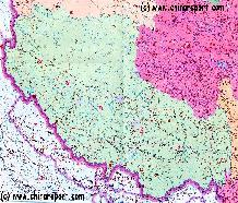
MapTibetHistoricalBorders
A Schematic Map of Historical Tibet, today Tibet Autonomous Region, Qinghai Province and a part of Sichuan province.
Included for reference are current International Borders, provincial borders, locations and names of main cities and towns, main rivers and lakes, mountains,importantTibetan-BuddhistMonasteries and other places of significance.
Further Reports link to More Photos and History & Backgrounds of each City, Town or Ethnic Community of Yugur, Dongxiang Tibetan, Lhoba, Kazakh, Mongol or others where available.
Today Tibet only exists as Tibet Autonomous Region of China. Tourist visits require an aditional visa !
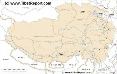
Tibet Autonomous Region Geographic Map 1A
This geographical Map gives a clear overview of Tibet Autonomous Region of China and immediate surroundings. including neighboring area's of Xinjiang-Uyghur Autonomous Region in the North-West, Qinghai Province in the East. Due to the South and South-West lies Sichuan Province and in the extreme South-West Yunnan Province. Surrounding Nations are many, small and large. These are Myanmar, Bhutan, Sikkim, Nepal, Bangladesh, India and Pakistan.
Map Includes Cities and Towns (shown by size), Main Monuments & landmarks of TibetAR, main mountains (with Height), major highways, provincial railroads and main railroad-stations and main waterways & rivers.
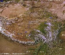
A SatelliteImage overview Map of the entireTibetanPlateauxincluding parts of bordering regions of Xinjiang-UyghurAR, Gansu Province, NingxiaHuiAR, Inner-MongoliaAR,Sichuan Province,andYunnan Province. Surrounding nations and Territories are: Myanmar (Burma), Bhutan, Sikkim, Nepal, Bangladesh, India, Kashmir and Pakistan.
This Map clearly defines Provinces and Regions, main mountain ranges, main rivers & lakes of the region, locations of main cities and landmarks.
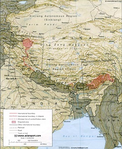
A geographic overview Map of Tibet, the Tibetan Plateaux and relevant adjoining regions and territories. Map includes a large part of Xinjiang Uyghur Autonomous Region (PRC), Kashmir, North-West Pakistan, Northern India, Nepal, Bhutan, Bangladeshand the culturally associated region of Myanmar (Burma). A small part of Yunnan Province of China is also depicted.
This Map clearly defines disputed borders and territories, Nations (except for Tibet), Provinces and Regions, as well as geographical features such as main mountain ranges, main rivers & lakes of the region, basins and plains, plus the locations and names of main cities, towns, monuments and landmarks.
Browse the Map and follow the Links where available to access more maps, information and photos on each location and landmark.