Location : (Coordinates: 36°30′ North 102° 07′ East)
Elevation : No information available.
Surface Area: 750 square kilometers.
Urban - No information available.
County of Ping'An - No information available.
Population: According to the according wikipedia page the Total Urban Population of Ping 'An& County was around 110 thousand souls in the year 1999. Due to an ongoing migration of Han Chinese into Tibet including Qinghai, this number has risen since. In 2010 the population is reported to have grown to 120,000 persons.
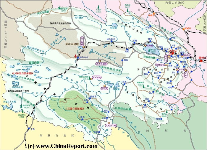
Ping'An is a relatively large town located in the predominantly Tibetan area's along the rim of the Qinghai section of the Tibetan Plateaux in the area between Xining, the Capital of Qinghai Province, and Lanzhou
The China Report
The Ping'An Report is part of the overall website www.ChinaReport.com & www.drben.net
Learn about what is new on this Site from below window.
ChinaReport.comat
The main Landmarks and Monuments of Ping'An Town are the White Horse Temple.
Tourism wise Ping 'An County is renowned for the spectacular landscape of rice paddies set along the fertile rim of the Tibetan Plateaux. In addition, various ethnic groups, dubbed "minorities"by China and their according architectural styles are also a major attraction. Apart from the White Horse Temple in the town of Ping 'An itself, there is a major lamaist monastery situated in the mountains of the Ping'An County.
As the largest town of Haidong Tibetan Autonomous Prefecture and situated near the main Lanzhou to Xining (Lanxi) Highway (and railway) the town of Ping'An is relatively easy to visit and thus provided an opportunity for adventurous tourists to explore the region in reasonable comfort. Most tourist are Han Chinese from the overpopulated inner Provinces dying for some fresh air and some standardized cultural trips. Western tourists are far more scarce and prefer to get around exploring the villages in search of the lifestyles that now increasingly belong to yesteryear.
A Full listing of Ping'AnandCounty Landmarks, Monuments, Hotspots and other sites of importance in alphabetical order. Search through the list to find your Full Report and Photo-Virtual Tour of each monument or landmark within the City, or Region of Ping'An in HaidongPrefecture, Qinghai Province of China (PRC).
Public Transport in Ping 'An & County
PING 'AN TRAIN STATION:
The Main and only Railway Station of Ping'An is situated on the North End of Town. It is pretty hard to miss. Just follow the tracks.
Ping'An
Ping'An has a Railroad Station.
For air-connections the Town relies on nearby Xining National Airport. A possible alternative is the National Airport North of Lanzhou.
Since the year --- Ping'an County (平安县) is an administrative district in Qinghai Province of the People's Republic of China. It is one of 43 counties of Qinghai. It is part of the Haidong Prefecture, with the city of the same name being the prefecture seat. Its postal code is 810600, and its population in 1999 was 110,154 people.
ADMINISTRATIVE DIVISION:
Ping'An is relativel small with a surface area of 750 square kilometers. It is one of the 6 counties that make up the Haidong Tibetan Autonomous Prefecture of Qinghai Province. Within this prefecture, respectively Ping'an - seat of the county Government, and Ledu are the most important and influential districts. The other counties of Haidong Tibetan Autonomous Prefecture are regarded as 4 special zones identified as autonomous counties for their majority ethnic populations. The Autonomous Counties in Haidong Prefecture surrounding Ping'An county are the Minhe Hui and Tu Autonomous County, Huzhu Tu Autonomous County, Hualong Hui Autonomous County, and the Xunhua Salar Autonomous County.
The County administered from the town of Ping'An counts 8 sub-divisions. The first sub-division is the town of Ping'An itself. Followed by the rural Towns of and villages of Sanhe (三合镇), Xiaoxia Town (小峡镇), Bacanggou Hui Ethnic Township (巴藏沟回族), Shagou Hui Ethnic Township (沙沟回族乡), Gucheng Hui Ethnic Township (古城回族乡), Shihuiyao Hui Ethnic Township (石灰窑回族乡), Hongshuiquan Hui Ethnic Township (洪水泉回族乡).
PARKS:
Xihai south park; XiHai translates as "West Lake". The Park and water are situated along the south bank of the Huangshui River in the town of Ping'An.
Ping'An Xia Temple group forest park; no additional information available on location and available sights and relics.
MAIN STREETS AND ROADS OF PING'AN TOWN:
Hualong Road, Yangjia Road, Ping′a Express, Sanhe Alley, Ping'an Road, Ledu Road, Provincial Highway 2, Gucheng Alley and Guyi Boulevard.
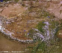
Tibet-TibetanPlateaux-SatelliteImageOverview 1A
A SatelliteImage overview Map of the entireTibetanPlateauxincluding parts of bordering regions of Xinjiang-UyghurAR, Gansu Province, NingxiaHuiAR, Inner-MongoliaAR,Sichuan Province,andYunnan Province. Surrounding nations and Territories are: Myanmar (Burma), Bhutan, Sikkim, Nepal, Bangladesh, India, Kashmir and Pakistan.
This Map clearly defines Provinces and Regions, main mountain ranges, main rivers & lakes of the region, locations of main cities and landmarks.
There is currently no information available on climate and weather in Ping'An specifically. Please refer to 'Climate and Weather in Qinghai Province' for the best available data.
Tourism wise Ping 'An County is renowned for its various ethnic minorities and their according architectural styles. The offically listed nationalities of the county are: Han, Tibetan and Hui.
As the largest town of Haidong Tibetan Autonomous Prefecture and situated near the main Lanzhou to Xining (Lanxi) Highway (and railway) the town of Ping'An is relatively easy to visit and thus provided an opportunity for adventurous tourists to explore the region in reasonable comfort. Most tourist are Han Chinese from the overpopulated inner Provinces dying for some fresh air and some standardized cultural trips. Western tourists are far more scarce and prefer to get around exploring the villages in search of the lifestyles that now increasingly belong to yesteryear.
Whereas immigrated Han Chinese prefer to stick to the main towns where they can lve in reasonable comfort and in reach of facilities, Ping' An County, not the town, has a sizeable population of Tibetan inhabitants.
No additional information available.
No information available.
Find DrBen and ChinaReport on Facebook with the latest from www.drben.net.
, the Capital City of neighboring Gansu Province. It is bordered in the north west by Menyuan Hui Autonomous County of Haibei Tibetan Autonomous Prefecture and to the west by Xining Prefecture of Xining, the Capital of Qinghai Province and also the largest city of that Province.