Main Rivers and Waterways of Xinjiang-Uyghur Autonomous Region :
Main Cities & Population Centres of Xinjiang AR :
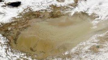
Although the central region of Xinjiang is made up by the Taklamakan Desert and among the dryest and most dangerous desert regions in the world, the Xinjiang Autonomous Region counts many rivers and springs which throughout the last two millenia have sustained life in these remote and rugged regions.
Springing from the mountain gletsjers atop the surrounding high mountains.
The main river in Xinjiang is the Tarim River, which runs through the tarim basin and along the Taklamakan Desert in the south of Xinjiang Region. The Tarim is China's westernmost river and ranks as the fifth longest river in China. Fed by melting water from a variety of rivers along its route, the Tarim river flows roughly from Kashgar in the West, along the north rim of the Taklamakan Desert, eastward to end up near the Lop Nor wandering salt lake and the silk road town of Dunhuang, near the Western border of Gansu Province.
Historically speaking, the Tarim river was a lifeline of water providing a viable road to the East in these outright barren regions, providing a backbone for the Silk Road along its most dangerous and lethal section. Around the year 1900 AD, when it was rediscovered by the Norwegian explorer Sven Hedin, the lake still held water. However, as recorded, the lake later dried out and today much of the Tarim river suffers a similar fate throughout much of the year. Local Governments and authorities are trying to deal with this problem, with little success.
Among the famous historic cities and sites along the Tarim River are the city of Kashgar (upstream section), the towns of Tarim, Hadadun and the ruins of the ancient lost town of Miran are located in the outflow section of the Tarim River, the once large and bountyful Lop Nor, now a salt lake. Along the length of the river many Silk Road relics are found and there are various sites with fairly unknown and unvisited Buddhist Caves.
Other rivers in the South of Xinjiang AR are the Yarkent River, the Kashi (Kashgar) River and the Aksu River in the far West, the Hotan, Keriya and Niya and Cherchen Rivers flowing from the Kunlun Mountains and the Tibetan Plateux into the south rim of the Taklamakan Desert in the
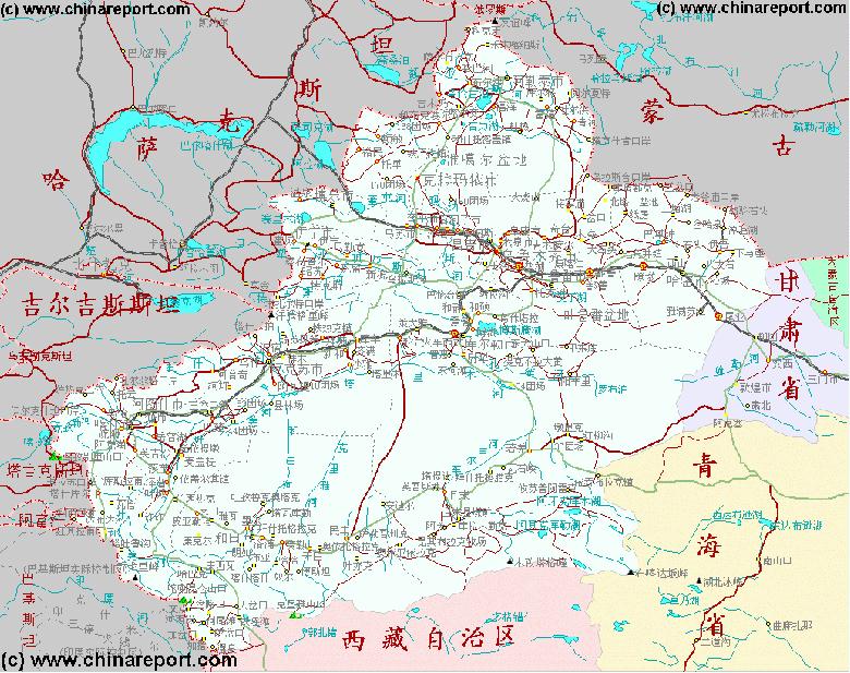
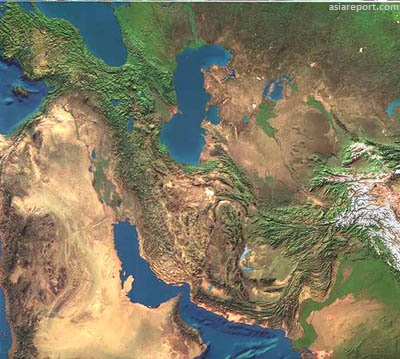
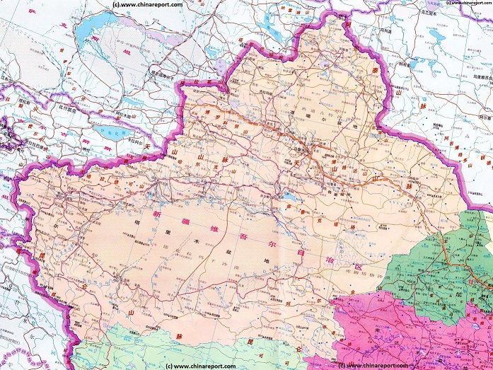
By surface area, the Xinjiang-Uyghur Autonomous Region is the first and largest territory within the Peoples Republic of China. Roughly, it makes up 1/6 Th of the total surface area of the Peoples Republic. Xinjiang (شىنجاڭ), as the territory is known by its Uyghur inhabitants lies in the Far West of China, separated from
Introduction to Xinjiang (شىنجاڭ) Uyghur Autonomous Region of China
of the two top-secret US lectronic signal (SIGINT) monitoring sites in Xinjiang, one at Qitai and the other Korla
These listening posts were manned by Chinese Nationals trained by the US Government to monitoring Soviet missile tests and other communications, electronic signals that the americans were unable to aquire after the Iranian revolutionaries closed down
Tracksman 1 and 2 in Iran.
The Top-Secret listening Stations in Qitai and Korla apparently continued their electronic spying operations until the end of the Soviet occupation of Afghanistan in 1989 AD.
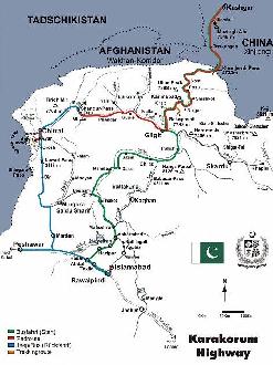
Construction and opening of the Karakoram Road or Highway, leading directly from Kasghar in Xinjiang to the Capital of Pakistan at Islamabad, traversing some of the highest mountain passes in the world.
Overview Map of the very large expanse of the Xinjiang-Uygur Autonomous Region of China (P.R.C.) and surrounding area's. Click Map Image for Full Sized Version.
neighboring nations by high mountain ranges famous from Chinese and World history. Neighboring nations and territories of Xinjiang are many. The neighboring nations of Xinjiang are in clockwise around order; the Jammu & Kashmir Regions of India (disputed) in the South-West, the countries of Afghanistan and Tajikistan in the West, Kyrgyzstan to the North-West, Kazakhstan to the North-North-West, a narrow border with the Russian Federation in the North, and finally the Republic of Mongolia to the North and North-East. Neighboring Chinese Territories are Inner-Mongolia Autonomous Region to the North-East, the narrow strip of Gansu Province in the East, Qinghai Province to the South-West and finally Tibet Autonomous Region of China to the South.
Known as the Western Territory (Xin Jiang) since the earliest periods of the Han Dynasty (206 BC - 220 AD), when Han China first started its opening and exploration of the Silk Road paths in Central
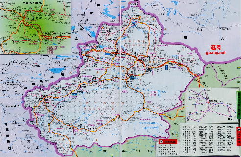
Altai
Mountains
Overview Map 2 - Schematic Map of Xinjiang Autonomous Region and surrounding area's. Click for Full Sized Version.
Gobi Desert
Taklamakan Desert
Tibetan Plateaux
X <-Lop
Nur
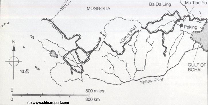
A Schematic Map of the Several Layers of the Great Wall of China defenses as they existed during the Ming Dynasty (1368 AD - 1644 AD) in Gansu, Qinghai, Ningxia, Shaanxi, Shanxi and Hebei Provinces. Map includes location of + link to Great Wall Passes as reported on by ChinaReport.com. Mouse over & Click Links for more Information and Photos.
Yang Guan Pass
Jia Yu Guan Pass
X
YaMen Guan Pass
Pian Guan Pass
Ordos Desert
TengGer Desert
Taklamakan Desert
Gobi Desert
Gobi Desert
Gobi Desert
Ngoring Hu
Wei River
In the 1950's, Xinjiang Uygur became the scene of large scale and secretive military works. Apart from the task of guarding the border and strenghtening infra-structure for the Peoples Liberation Army, the main purpose of the military activities in these far western region was the building and developing of a (almost) home-grown Chinese Nuclear program.
During the later stages of this development, the remote strecthes of the Taklamakan Desert on the border between Gansu, Inner-Mongolia Autonomous Region and Xinjiang Autonomous Region were chosen as the best location for nuclear testing and related secretive military activity.
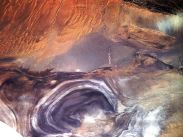
The first Chinese nuclear-weapons test site was located at Lop Nor, where in the 1960's China's first crude nuclear device was exploded.
Lop Nor is situated near the entrance to the historic Hexi corridor running down from the High North near Lop Nur and Dunhuang, wedging between two mountain ridges and bending around the Heights of the Qinghai Plateaux to descend down and end at Lanzhou.
This section is dry and arid and often windy, and consist of barren graveled lands and salt lakes. Rivers, formed by melting waters from nearby mountains cut across the plain, but waters rapidly flow downstream to end up in the Yellow River (Huang He) near Lanzhou.
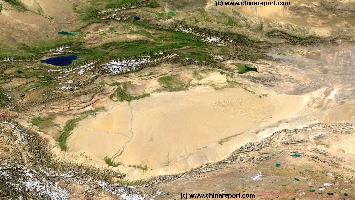
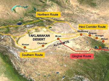
China Report - Map o/t Taklamakan Desert & Tarim River Basin
A Satellite Image Map of the entire Taklamakan Desert and the Tarim River Basin in Xinjiang-Autonomous Region of Western China.
Map gives explanation and backgrounds to Local Geography, the Flow of the Tarim River from the Pamir Mountains in the West to Lop Nur (Dry) in the East, ancient Oasis Cities of the Tarim Basin and Taklamakan Desert, the North and South Routes of the Silk Road in this Area, Past and Current Climate and Historic Backgrounds.
Yellow River
Yellow River
Yellow River
YaDan Land-forms
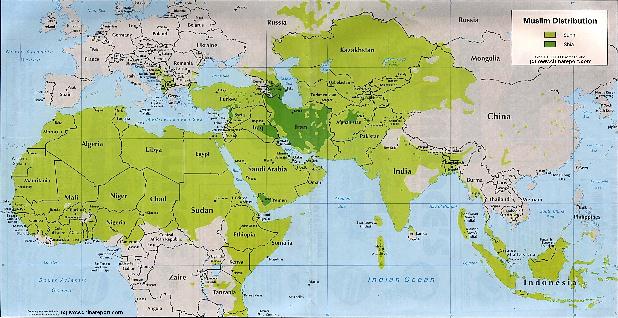
Asia Report - Maps - Distribution Islamic Faith Asia, Africa , Europe
A Geographic Map depicting the Distribution of the Islamic Faith in China and Asia, as well as Europe and the majority of the continent of Africa.
Sunni Islamic Areas are depicted in Green, whereas the Shia (Minority) Areas are depicted Darker Green.
The predominantly Muslim Xinjiang-Uygur Autonomous Region of China, Parts of Gansu Province and Small Ningxia Hui clearly stand out as the main muslim areas in China.
Wakhan peninsula, where Afghanistan and China briefly touch each other along a 40-mile border, which snakes its way through deep mountain gorges. The Wakhan’s towering, icy peaks
are mostly over 20,000 feet high, and thinly populated. All of the valleys on the Afghan Border are cut off by snow and ice for months in the winter.
There is an Afghan proverb which says “even the birds can use only their feet” along the corridor’s 120-mile length.
At the time the Afghan jihad began, the 3,000 or so inhabitants, living in the
valleys of the Hindu Kush mountain range and the edge of the Pamirs, were Muslim
Kirghiz tribesmen. They were ethnically affiliated with the people of the then
Kirghiz Soviet Republic, now independent Kyrgyzstan. These hardy mountain
people also enjoyed occasional trade and other contacts with the Kirghiz and
Uighur people next door in China’s Xinjiang.
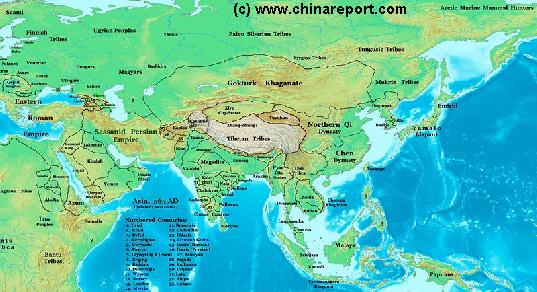
China Report - Map of Ancient Asian Empires and Tribes in Asia 565 AD
An overview Map of Asia Entire clearly demarkating the Territories, Nations and Tribal Area's of the Continent in the year 565 AD. Japan is split between the Yamato Kingdom and Emishi. In Korea three Kingdoms Rule among which the largest Goguryeo. China is split in a Northern Dynasty of the Qi, and a Southern Dynasty of the Chen. While in the Far west the Qi Empire stretches as far West as Dunhuang, the Silk Road is temporarily blocked by the unification of Mongol Tribes in the Gokturk Khanate and the appearance of the small XiYe City State in the Tarim River Basin.
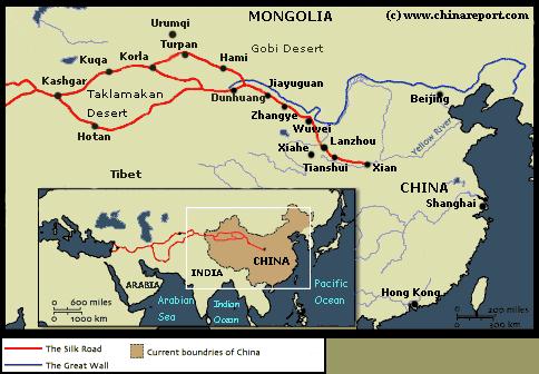
Schematic Map of the many sub-pathways of the Silk Road in China clearly showing the one-unavoidable pathway of the Hexi Corridor.
Qilian Mt Range
Mazhong
Mt Range
Taklamakan Desert
Qinghai Plateux
Gobi Desert
Gobi Desert
Tibetan Plateux
Tian Shan
Mt Range
Soundbonus - Traditional Chinese Folk Song from Xinjiang-Uygur Province, the "Flower of Hsin-Jiang" (Bamboo Flute).
A Full and complete Map of China (PRC) identifying all Language Areas big and small in all Provinces and Autonomous Regions of China.
Map includes Turkic Languages (Uygur, Kazakh, Kirghiz, Salar & Uzbek), Mongolian Language and Sub-Divisions (Mongol, Tu, Daur and Dongxian), Tungusic Peoples (Oroqen, Evenki and Xibe) and Languages, Korean, Tajik (Tadzhik), Mon-Khmer (Kawa + Puman (or Pulang)), Hui, Uygur (Uighur), Tibeto-Bhurman Languages, Tai and Miao, Yao and She' Language Area's and Borders. Main Area's and sub-divisions of Han Languages (Northern Mandarin, Eastern Mandarin, South-Western Mandarin and Cantonese) further included. This color-coded ethno-linguistic Map (of 1967 AD) identifies at a glance most ethnic minority regions in China
Map China Ethno-Linguistic / Language Distribution China
Full Google Map of the Lop Nor nuclear testing area in Xinjiang-Uyghur AR
MapTibetHistoricalBorders
A Schematic Map of Historical Tibet, today Tibet Autonomous Region, Qinghai Province and a part of Sichuan province.
Included for reference are current Internationa Borders, provincial borders, locations and names of main cities and towns, main rivers and lakes, mountains,importantTibetan-BuddhistMonasteries and other places of significance.
Further Reports link to More Photos and History & Backgrounds of each City, Town or Ethnic Community of Yugur, Dongxiang Tibetan, Lhoba, Kazakh, Mongol or others where available.
Today Tibet only exists as Tibet Autonomous Region of China. Tourist visits require an aditional visa !
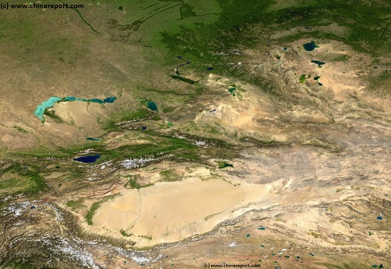
Asia Report - Map Image of West Xinjiang AR & Central Asian neighbors
This Satellite Image provides a clear overview of West Xinjiang, Taklamakan Desert, North Pakistan, Afghanistan, Tajikistan, Kyrgyzstan, Kazakhstan and a large section of the (southern parts) Russian Federation.
Marked on the map for orientatation are the names of major National and Provincial Capitals, cities, several towns and villages, oceans, sea's, lakes and rivers, as well as mountains, national borders, and locations of interest.
Browse the map and follow the links to more information, maps and photos of each location.
Find DrBen and ChinaReport on Facebook with the latest from www.drben.net.
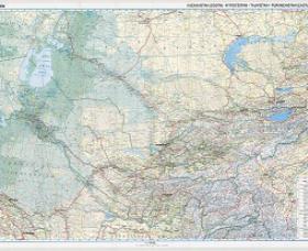
Asia Report - Map Roads & highways in Central Asian Nations
A geographical and topographical overview Map of the Central Asian Nations of (South) Kazakhstan, Tajikistan, Kyrgyzstan, Uzbekistan, Turkmenistan, and Parts of North Iran, North Afghanistan, North Pakistan, North India (Jammu & Kashmir), and the region of Kashgar (Kashi) in West China's Xinjiang-Uyghur Autonomous Region of China.
Map includes International Borders, national provinces and regions (where possible), main cities and roads, main lakes and waters, as well as the locations of Historic Sites, wildlife reserves, officially designated ethnic autonomous communities, main mountain peaks with heights and more coming soon !
Browse the Map, click and follow the links to additional information on each site and location. Click on selected highlighted Map sections for a more detailed map of that Region. Explore the connections in central asia as never before !
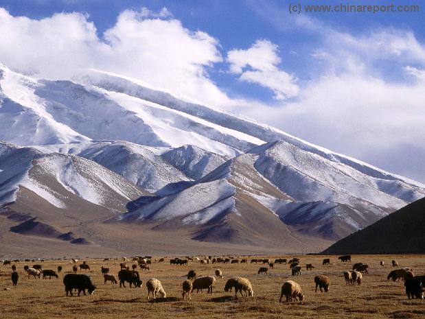
As the largest territory within The Peoples Republic of China, Xinjiang AR comprises a huge surface area and includes a variety of climates and landscapes. From the wind-blown plains and endless sand dunes of the Taklamakan Desert, to green and lush Oasis Towns, to some of the highest mountain peaks in the world found in the mountain ranges that make up much of the Chinese border, Xinjiang has it.
Geographically speaking , the central regions of the Xinjiang Region are made up by the sandy and rocky expanses of the Taklamakan Desert, where as its borders are naturally shaped by high mountain ranges. In the south these Mountains are the Himalayan Mountains and Kunlun Mountain Range which
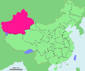
Schematic Map showing the location of Xinjiang Uyghur Autonomous Region within the Peoples Republic of China.
History of Xin Jiang, the Western Territory :
Most, if not all cities and large population centers worth visiting are situated among ancient trecking routes of the region, together forming the pathways of the Silk Road.
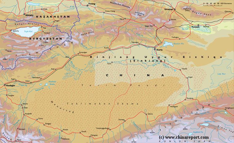
The main cities in Xinjiang Autonomous Region are the Capital Urumqi - which lies almost central in the large region, Kashgar - which is China's westernmost City and Aksu, along the Aksu river, a tributary of the Tarim River in the south. Other cities or large population centers in the region are the ancient Oasis Town of Turpan, the city of Karamay along the trade route to the North into Kazakhstan, Yining - the Capital of Ili-Kazakh Autonomous Region situated along the main road to the North-West into Kyrgyzstan , Uzbekistan and Kazakhstan, and last: Shihezi.
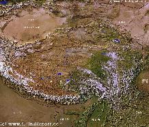
A SatelliteImage overview Map of the entireTibetanPlateauxincluding parts of bordering regions of Xinjiang-UyghurAR, Gansu Province, NingxiaHuiAR, Inner-MongoliaAR,Sichuan Province,andYunnan Province. Surrounding nations and Territories are: Myanmar (Burma), Bhutan, Sikkim, Nepal, Bangladesh, India, Kashmir and Pakistan.
This Map clearly defines Provinces and Regions, main mountain ranges, main rivers & lakes of the region, locations of main cities and landmarks.
run along the Westernmost Edge and northern rim of the large Tibetan Plateaux. In The West various mountain ranges ply together into the Pamir Mountains and the Karakoram Range. To the North of the Taklamakan Desert lies the famous Tian Shan Range, or Heavenly Mountains forming the border with Kyrgyzstan and Kazakhstan. In the Northern reaches of the Xinjiang - western territory lies what is known as the Ili-Kazakh Region, which includes the Dzungar(ian) Basin and is separated from Kazakhstan by the high Mountains of the Altai Range. The Ili-Kazakh Region forms an enclave
Topographically speaking the huge region of Xinjiang is often divided into the North and the South, taking the regions in the South as everything surrounding the Taklamakan desert and the Tarim River Basin, whereas the North is then made up by the triangle of the Ili Kazakh Region, which includes the Dzungar Basin - a high mountain plateaux and desert which is similarly disected by various rivers and mountain streams.
Demographically speaking Xinjiang can be divided into a variety of ethnic autonomous regions. The Main ethnic divisions within the Xinjiang Region are between the Kazakhs, Tajiks, and Kyrgyz (Khirgiz) in the West and North-West of the Region and the Uyghur and Mongolians in the central and eastern regions of the Province. For a correct understanding of the ethnic divisions and relations within Xinjiang Region, please refer to our section on the Ethnic Minorities of Xinjiang AR (below).
China Report - Map o/t Tarim River Delta - Lop Nor dried lake area in Xinjiang AR
A simple satellite image depicting the outflow of the Tarim River into the (former) Lop Nor Lake.
Climate in Xinjiang AR :
Generally, the climate in Xinjiang is taken to be semi-arid or desert climate and Xinjiang has no less than 3 desertous area's, the huge sandy and barrenTaklamakan Desert in the Tarim River Basin in the south, the Dzoosotoyn Elisen Desert and the Kumtag Desert in the Dzungar Basin of the North.
the largest of which is the Taklamakan. The region is marked by great seasonal differences in temperature. In practice climate and temperatures depend much on location and elevation. Summers in Xinjiang are searing hot and temperatures routinely rise above 40 Degrees Celcius. Winters in Xinjiang are cold and harsh, especially in the North. Thick snowfall often causes avalanches, and makes travel throughout the mountainous regions of the Province difficult.
Economy of Xinjiang-Uyghur Autonomous Region :
No information available at this time.
Transportation & Travel Connections in Xinjiang-Uyghur Autonomous Region :
RAILROADS IN XINJIANG AUTONOMOUS REGION:
No information available at this Time.
ROADS AND HIGHWAYS IN XINJIANG AR:
No information available at this Time.
AIRPORTS IN XINJIANG AR:
Kashgar and Urumqi have International Airports.
No additional information available at this Time.
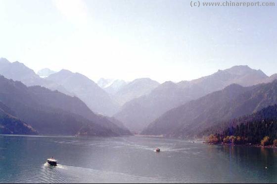
The Xinjiang Region is home to several of China's famous and scenic lakes, as popular legend would have it surrounded by the likes of the happy and exotic tribes of the Kyrgyz, Uzbek, Tajiks, Kazakhe, and Eluosi, the latter descendants of Russian migrants into the Region. These famous lakes are Bosten Lake, Manas Lake and less famously because of its extreme remoteness, the Ulungur Lake.
South. All of these, except for the Niya and Cherchen rivers ultimately end up as tributaries to the Tarim River, all historically flow out into the now usually dried up Lop Nor (Salt Lake).
Rivers in North Xinjiang Region are slightly less easily described and understood.
Ulungur River in the extreme North.
The Chinese history of the Regions that today make up Xinjiang begins as early as the Han Dynasty (206 BC - 220 AD), however as described on our Chapter on the Silk Road, the history of the trading paths from the west and Central Asia into China goes back considerably further, to the invention of the wheel and the animal-drawn cart which for the first time enabled or at least greatly facilitated long distance travels.
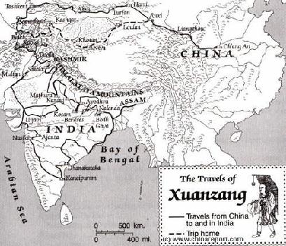
Later, during the Tang Dynasty era, a Chinese Monk named Xuanzang traveled along the silk road pathways to find his way into India. Bringing back invaluable knowledge and a huge library of scriptures, he became famous in history as a teacher and Professor of Buddhism in the then Capital of China, Chang' An.
In the 13Th Century the renowned European traveler and explorer Marco Polo traveled through the City of Kashgar and the Xinjiang Region on his way into the Han Chinese Nation and the Mongol Khanate of Cathay.
In the 17Th Century a lesser known European traveler named Bentos De Goes made roughly the same harrowing journey.
At the end of the 19Th Century and in the beginning of the 20Th Century, the region of Xinjiang would become part of what today is often refered to as the 'Great Game' for Central Asia. During this period a variety of international explorers tried to reach the remote far western region, mapping, digging and recording as they went. Apart from several Russian explorers, the West was best reconnoitered by Sven Hedin and (Sir). Marcus Aurel Stein who left large volumes of historicly valuable information.
In the beginning of the 6Th Century AD, during the rise of a new centrally organized Dynasty in China, the Tang Dynasty, much of the territory of what is today the Illi kazakh Region of (North) Xinjiang fell under control of wild barbarian tribes, which previously has organized into the so called Gokturk Khanate, an alliance of Central Asian and Mongolian Tribes.
The Silk Road pathways leading from China into Central Asia were further explored and invaed by the Han Chinese during the turbulent rise of the Tang Dynasty (608 AD - 907 AD), its armies eventually reaching Buchara and Samarkand, and setting up camp along the Southern Shores of the Caspian Sea.
On the renewed econmic succes of the Silk Road and unprecedented International Trade of Chinese goods, the Tang Dynasty saw a highpoint of Chinese military, economic and cultural power, extending Chinese influence far into Central Asia and onto the Tibetan Plateaux. In this period, the Western Region of Xinjiang for the first time was solidified into
the Chinese Empire. Although still inhabited by 'foreign and exotic tribes' and the territory of bandits, robbers and murderous rebel uprisings, Tang Dynasty armies set up military bases in the region on a large scale, setting up fortress farms where immigrants sent from afar could farm their lands and develop the economy, while doing wartime duty in times of tension. During the highpoint of this Era, the Great Wall of China extended beyond today's Great Wall of the Ming Dynasty (1368 AD - 1644 AD) Era, reaching well beyond Jiayuguan in neighboring Gansu Province and the current end of the Great Wall of China to reach Dunhuang (Gansu), and from there extend into the Xinjiang Region all the way to the then large expanse of the Lop Nor, not only a lake but a region of extensive marshes deadly to any army. As it is commonly understood today, a long string of Fire-Beacon Towers extended the protection offered by the Great Wall even further along the economic artery of the Silk Road.
As may be deduced from the above introduction there are many aspects to life and travel within the Xinjiang Region, which vary much depending on location and situation.
Historic sites abound but often lie far apart, Monuments are surprisingly few mainly due to historically low population numbers and harsh local climates, but scenic sights such as wild landscapes, remote villages and snowcapped mountains reflected
in clear water lakes are often a rule rather than exception. Overall, Xinjiang is known for its astounding natural beauties and exotic mix of ethnic tribes rather than for its impressive architectural wonders or other man-made monuments.
As for the highlights of the Region, the absolute top is comprised by the various historic sites and cities of the Silk Road. Although in principle these are many and far betwen, the Jewel among these is of course the far western City of Kashgar. Kashgar is renowned in time as a crossroads of cultures and market town on the silk road. Other sites are dispersed
throughout the region and lie along both the North Rim and the south rim of the Taklamakan Desert (which is situated in the center of what is called the Tarim River Basin). The most famous and most well-visited of these are Turpan and Hami (and to a lesser extend Kuchar or Korla), Oasis towns situated along the lifeline of the Tarim River which makes up the northern route of the main line of the silk road reaching West, and famous for their historic mentions as well as their Buddhist Art. Although today connected by roads and highways, the Towns and ancient Cities of the southern route of the Silk Road leading around the Taklamakan Desert remain much less visited. Although famous from history books the towns of the southern route lie largely abandoned due to drying of the Lop Nor lake and subsequently the Cherchen and Hetian Rivers. The historic sites along the route offer mere sand-blown ruins and there are no known locations of Buddhist Caves along this long stretch of road and route.
No doubt ranked as the second treasure of the Xinjiang-Uyghur Autonomous Region is its truly rich variety of ethnic Cultures.
Various ethnic groups such as the Tajike, the Kyrgyz, the Uzbeks, the Eluosi, Kazakhe, Mongolians, Tibetans and others inhabit the region with their semi-nomadic lifestyle and ancient cultures, and many a tourist and traveler, Chinese or otherwise, falls in love with the peoples and cultures of this extremely remote and large region of China.
The Third large attraction of the Xinjiang Region to travelers is no doubt its huge variety of spots of remarkable natural splendor and wild beauty dispersed throughout the large region.
More recent 'tourist attractions' have been the extends of the Karakoram Highway, and further some recently opened historic sites related to the history of the Chinese nuclear program.
Find Out in detail about the Landmarks, Hotspots, Monuments, Tourist- and Scenic sites within Xinjiang on our Dedicated Page !! >>>.
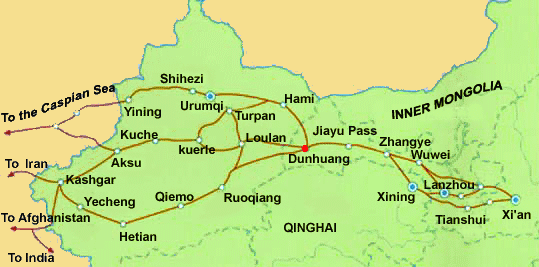
Satellite Image Map with super-imposed the main routes of the Silk Road leading traversing from West to East and Vice Versa. There are two routes circumventing the Taklamakan Desert in the North, and only one in the South.
A (dated) Goegraphic Map of Xinjiang-Uyghur Autonomous Region with its main population centers, roads and railroad, connections, airports, and main geographical features.
- CLICK MAP TO GO TO FULL VERSION !!! -
Manas Lake
Ulungur Lake
Bosten Lake
Tarim River
Lop Nor
Salt Lake
Yarkant
River
Hotan
River
Kheriya
River
Cherchen
River
Niya
River
Asia, Xinjiang has long been a territory disputed between various nations and tribes in history. 'Liberated' from Foreign -mainly Russian- influence and a Muslim Nationalist Movement by the Peoples Liberation Army in 1949 AD and finally established as the Xinjiang-Uyghur Autonomous Region of China on November the 1st of 1955 AD, today it is one of the most ethnically diverse territories within the Peoples Republic. The majority of its inhabitants is of Uyghur origins and many native tribes and ethnic groups are of the Islamic Faith. They share a common faith as well as a strong bond with their fellow nations across the border.