This page was last updated on: May 31, 2017
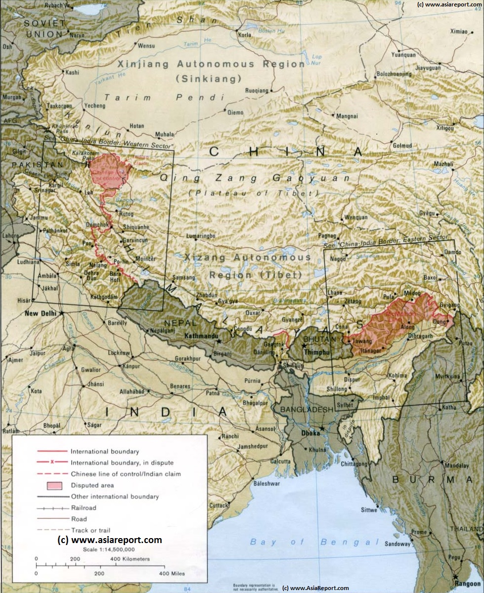
The below Geographic Map gives an overview of the Nation of Tibet, The Tibetan Plateaux and all relevant surrounding regions while clearly depicting the location and extend of all still disputed territorial zones. The disputed Regions are the Territory of Kashmir (disputed by China, India & Pakistan), Aksay Chin (Traditionally a part of Tibet or India, but invaded by China in 1962), long stretches of the Indian-Tibetan border (now falsely claimed by China) in the East, and traditionally Tibetan area's of Himachal Pradesh State of India also disputed by China (P.R.C.).
Tibet is currently an occupied Nation and territory which is part of the Peoples Republic of China (P.R.C.). The military occupation of Tibet brings the Peoples Republic of China in direct contact with the Republic of India. Since the brief war of 1962, border incidents have kept recurring and the border has been heavily militarized with the Peoples Republic improving transport connections with Tibetan Cities, colonizing the region with Han Chinese immigrants and building dual use airports at high altitude, while India responded by raising a large mountain warfare army which now guards the frontier.
The China Report
Geographic Overview Map of Tibetan Plateaux & Regions explained
Nyingchi
Dunhuang
Jiayuguan
Mandalay
Shigatse
Ganges
Indus
Ho Sai Hu
Mts.
(Pendi)
Hetian
Cherchen
Hotan
River
Bayan Har
Mountains
Hei
River
Qinghai
Hu
Hexi
   Corridor
JiuQuan
Jiuquan, Jiuquan Prefecture, Gansu Province, China (P.R.C.).
ChinaReport.com at
To Main Menu of All Websites at DrBen.Net
Go to www.drben.net webring
Dunhuang, Jiuquan Prefecture, Gansu Province, China (P.R.C.).
Taklamakan Desert
Kashgar (Kashi), Kashgar Prefecture, Xinjiang-Uyghur Autonomous Region
JiaYuGuan, Jiayuguan Prefecture, Gansu Province, China (P.R.C.).
Compare Maps for better comprehension - Follow Link & Click through to more Information & Details
Gobi Desert
Xinjiang-Uyghur AR
Tibet Autonomous Region
NEPAL
BANGLADESH
MYANMAR
Yunnan
Qinghai
BHUTAN
SIKKIM
Pakistan
Kashmir
Yellow
River
Altyn Tag
Kunlun
Mountains
Mountains
Qilian
Da Qaidam
Mountains
Golmud, Golmud Prefecture, Qinghai Province, China (P.R.C.).
Tarim River
Keriya
River
Cherchen River
Heng
Duan
Shan
Cherchen (Qiemo), Bayin-Gholin, Mongol Autonomous Prefecture, Xinjiang-Uyghur AR
Aksay
Chin
Mountains
Hetian, Hoton Prefecture, Xinjiang-Uyghur AR
Keriya (Mugala), Hotan Prefecture, Xinjiang-Uyghur AR
Keriya
Lop
Hoh
Xil
Brahmaputra
Brahmaputra
Simla (Lok Sabha constituency), parliamentary constituency, Himachal Pradesh, India
Patna (पाटलिपुत्र), Bihar, India
Yangtze
Yangtze
Shigatse, Tibet Autonomous Region, China (PRC)
Gyangste, Tibet Autonomous Region, China (PRC)
Brahmaputra
For your reference the Map includes the location of current National Borders and Provincial Borders, main Mountain Ranges which provide natural borders and limitations in the Region, main rivers and lakes, the location of major Cities.
Please Browse the Map and follow the Links to more information and Photos of each Location !
MtEverest - Qomaloba Feng
Gansu
Indus
Yushu (Gyegu), Yushu Tiberan Autonomous Prefecture, Qinghai Province
Ganges
Ganges
Yamuna
Lucknow, India
Benares (वाराणसी - Varanasi), Uttar Pradesh, India

AsiaReport.com - Mastermap of Asia (entire). weergeven op een grotere kaart
Find DrBen and ChinaReport on Facebook with the latest from www.drben.net.
DrBen Nijhoff | Maak je eigen badge
Dehradun (Hindi: देहरादून, Dehradoon), Capital city of the state of Uttarakhand, Republic of India
Dhaka, Capital of Bangladesh.
Yangon (Rangoon), Yangon Region, Former Capital of Republic o/t Union of Myanmar (Burma).
Thimpu, Thimpu District, Capital of the Kingdom of Bhutan.
Kathmandu, Central Region, Capital of the Kingdom of Nepal.
New Delhi, (Delhi) National Capital Territory, Capital of the Republic of India.
Bitganj (Nepali: बिरगंज), Parsa District, Narayani Zone, Kingdom of Nepal.
Nepalganj, Banke District, Kingdom of Nepal.
Darjeeling (দার্জিলিং ; दार्जीलिङ), Darjeeling District, West Bengal, Republic of India.
Gangtok (--), East Sikkim District, Sikkim, Republic of India.
Myitkyina, Kachin State, Union o/t Republic of Myanmar (Burma).
Katha, Katha Township, Katha District, , Sagaing Region (Division), Union o/t Republic of Myanmar (Burma).
Mandalay, Mandalay Region, Union o/t Republic of Myanmar (Burma).
Prome, Bago Region, Union o/t Republic of Myanmar (Burma).
Bago (Pegu), Capital of Bago Region , Union o/t Republic of Myanmar (Burma).
Thandwe (Previously: Sandoway), Rakhine State, Union o/t Republic of Myanmar (Burma).
Sittwe (Foremerly: Akyab), Rakhine State, Union o/t Republic of Myanmar (Burma).
Puta-O, Kachin State, Union o/t Republic of Myanmar (Burma).
Nur
Wensu (Also: Onsu), Aksu Prefecture, Xinjiang-Uyghur Autonomous Region
Kyrgyz
-stan
Gilgit (Urdu/Shina: گلگت), Gilgit-Baltistan, Islamic Republic of Pakistan.
Murgab, Gorno-Badakhshan Autonomous Region, Republic of Tajikistan.
Tajiki
-stan
Osh, Capital of Osh Province, Kyrgyzstan.
Kargil, Kargil District, Ladakh, State of Jammu & Kashmir, Republic of India.
Leh, Leh District, (Former Capital of) Ladakh, State of Jammu & Kashmir, Republic of India.
Mekong
Chamdo (Tibetan: ཆབ་མདོ་, Chinese: 昌都镇), or Qamdo, officially Chengguan (simplified Chinese: 城关镇, Chamdo County, Chamdo Prefecture, Tibet Autonomous Region, China (PRC)
Nagqu (--), Nagqu County, Nagqu Prefecture, Tibet Autonomous Region, China (PRC)
Click to go to Full Version !!
Map Tibet Nation & Historical Borders
A Schematic Map of Historical Tibet, after military invasion and occupation by China (P.R.C.) divided into Tibet Autonomous Region (TAR), Qinghai Province and a parts of Gansu Province, Yunnan Province and Sichuan Province.
Included for reference are current International Borders, provincial borders, locations and names of main cities and towns, main rivers and lakes, mountains, important Tibetan-Buddhist Monasteries and other places of significance.
Further Reports link to More Photos and History & Backgrounds of each City, Town or Ethnic Community of Yugur, Dongxiang Tibetan, Lhoba, Kazakh, Mongol or others where available.
Today Tibet only exists as Tibet Autonomous Region of China. Tourist visits to T.A.R. require an aditional visa !
Lhasa, Historic Capital of the Nation of Tibet - Currently: Capital of Tibet Autonomous Region (TAR), China (P.R.C.)
Korla (Mongolian: ᠬᠣᠷᠣᠯ ; Uyghur: Uyghur: كورلا شەھىرى Krohrain ; Chinese: 库尔勒 Kuerle), Capital of Bayin'gholin Mongol Autonomous Prefecture, Xinjiang-Uyghur Autonomous Region
Charqliq ( Uyghur: Qakilik or Charkliq ; Chinese: 若羌 Ruoqiang), Ruoqiang County, Bayin'gholin Mongol Autonomous Prefecture, Xinjiang-Uyghur Autonomous Region
Tibet AR Online Sources
Tibet AR Maps
Tibet AR
Lhasa Transport
Lhasa
Lhasa Home
Lhasa Hotels
Tibet AR Home
Lhasa Offline Sources
Ngari
Gar Home
China Offline Sources
AsiaReport.com Home
China Report Home
China Online Sources
China Online Store
China Maps
China
China Photo Galleries
China Report Club
Nagqu
Nagqu Home
Qamdo
Qamdo Home
Shannan
Nedong Home
Nyingchi
Nyingchi Home
Xigaze
Xigaze Home
Lhasa Sources
Lhasa Economy
Lhasa History
Lhasa Landmarks
Lhasa Maps
Amdo (Pagnag), Amdo County, Nagqu Prefecture, Tibet Autonomous Region, China (PRC)
Taxkorghan (Taxkurghan), Taxkorghan Tajik Autonomous Prefecture, Xinjiang-Uyghur AR
Madoi (Maduo (also: Mazhali)), Madoi County, Golog Tibetan Autonomous Prefecture, Qinghai Province, China (P.R.C.).
Starry
Sea
Wenquan, Wenquan County, Golmud Prefecture, Qinghai Province, China (P.R.C.).
Lhabagar (Bayi, also: Nyingchi), Nyingchi County, Nyingchi Prefecture, Tibet Autonomous Region, China (PRC)
Gar (Tibetan: Senggezangbo - སེང་གེ་ཁ་འབབ་ ; Chinese: Shiquanhe - 狮泉河镇),Gar County, Ngari Prefecture, Tibet Autonomous Region, China (PRC)